
Network VMT Calculator Overview and Methodology
Overview
Network VMT is defined as the vehicle miles traveled by all-vehicles within a specific geographic boundary. It can be calculated by multiplying the vehicle volume on each link by the length of the link in miles. However, local governments are often interested in a breakdown of network VMT by various attributes such as the type of trip (internal-internal, internal-external etc.) that generated the VMT. Practitioners may also need a breakdown of VMT by mode such as passenger and commercial.
Replica’s new Network VMT Calculator application makes it easy for our customers to calculate network VMT for any geography of interest. Customers can calculate network VMT breakdowns by trip type (II, IE, EI and EE), mode (private auto and commercial), home location, trip purpose, household income and time of day. Replica also provides a breakdown of VMT generated by electric vehicles vs. ICE (internal combustion engine) vehicles.
Trip Type Breakdown Example:
Let us consider the case where we want to calculate the network VMT for Washington County, Oregon.
- If a 10-mile trip starts within Washington County and ends within Washington County, this is considered an internal-internal (II) trip and all 10 miles are counted towards the total network VMT for the county.
- If a 10-mile trip starts within Washington County (7 miles) and ends outside Washington County (3 miles), this is considered an internal-external (IE) trip and only the miles driven inside Washington county (7 miles) are counted towards the total network VMT for the county.
- If a 10-mile trip starts outside Washington County (6 miles) and ends inside Washington County (4 miles), this is considered an external-internal (EI) trip and only the miles driven inside Washington county (4 miles) are counted towards the total network VMT for the county.
- If a 10-mile trip starts outside Washington County (3 miles) and ends outside Washington County (2 miles) but passes through Washington County (5 miles), this is considered an external-external (EE) trip and only the miles driven inside Washington county (5 miles) while passing through are counted towards the total network VMT for the county.
Methodology
Replica’s network VMT calculator uses our Seasonal Trip Table to calculate network VMT. Our seasonal trip table provides the origin and destination location of every trip and the network links they traverse to go from their origin to their destination. This allows us to count the number of vehicles on each network link and multiply that by the length of the link to calculate the VMT.
We use the origin and destination location to determine the trip type (II, IE, EI and EE) for each selected geography. Replica's seasonal trip tables also contain many other trip and trip taker attributes, which we use to further breakdown the network VMT by mode, purpose, time of day, household income and home location.
To learn more about our disaggregate seasonal trip tables, please visit Seasonal Mobility Model Methodology Extended (Places)
Validation:
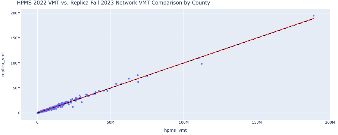
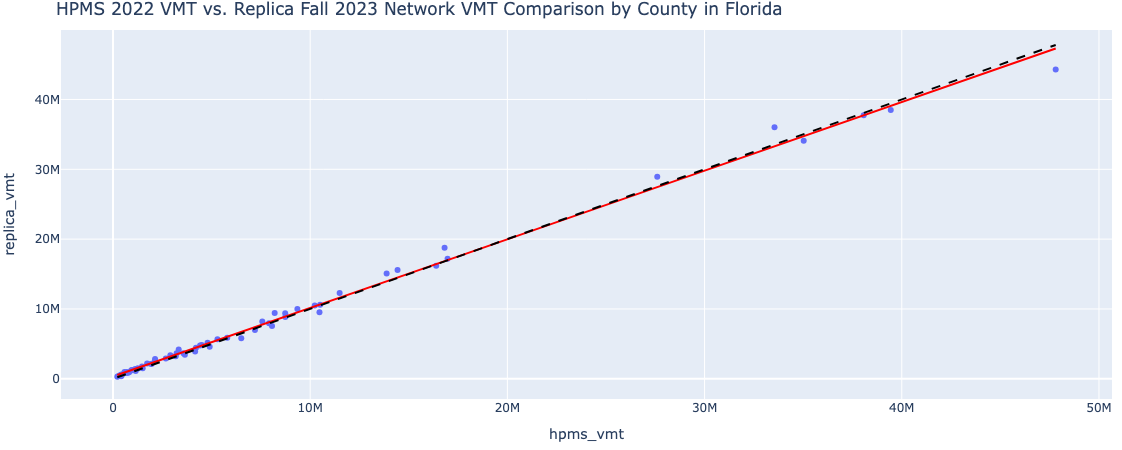
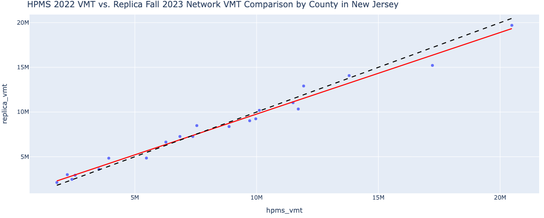
To validate Replica’s Network VMT Calculator application, we compared the county level daily network VMT produced by Replica to that produced by HPMS data, for every county in the US. The latest HPMS data available is for 2022 and latest Replica data is for Fall 2023. We use these two datasets to compute the network VMT for each county in the country and compare them. The scatter plot below shows the HPMS daily VMT on the x-axis and Replica daily VMT on the y-axis. The r-squared for the best-fit line is 0.99, showing a very high correlation between the two datasets. The dotted black line is the x=y line, which almost perfectly overlaps with the best fit line. This means that the datasets are not only highly correlated, they are also very similar in absolute numbers.
Please note that this comparison excludes the smallest roads in the network such as local_roads (f_system=7) in the HPMS network and residential roads in Replica’s OSM network. The reason for excluding this road class is to make the comparison more apples to apples. Replica’s OSM network contains more links and contains volume data for even small residential links, the equivalent of which does not exist in HPMS data.
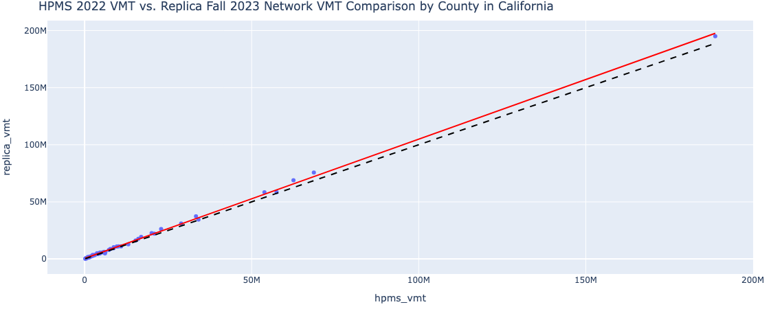
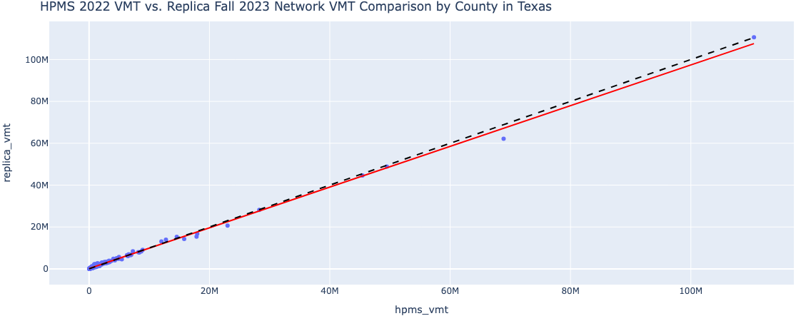
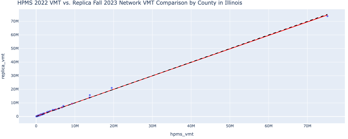
The following scatterplots shows regional fit for counties in several states.
Updated 8 months ago